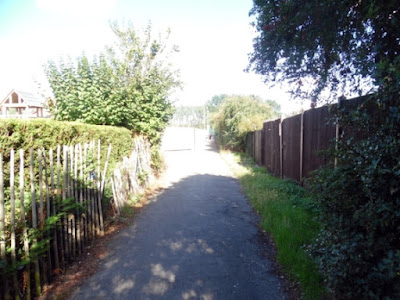
A weekend visit to Brigg Town Football Club's EC Surfacing Stadium and the nearby Recreation Ground got us thinking about the age of the lengthy footpath which borders both - running from Hawthorn Avenue alongside tennis courts towards the Rec.
The footway (also used by cyclists) is located behind the gardens of properties on East Parade and has a very mature Hawthorn hedge on one side.
The Rec was created by the Urban District Council in 1952 after it had bought the former Woodbine Farm, while Brigg Town FC established this ground in 1960/61, having used a venue behind the Brocklesby Ox pub on Bridge Street.
Did the footpath come into being between 1952 and 1961? Or was it there while the farm still existed?
Hawthorn Avenue's houses were completed by the UDC circa 1930.
So we wonder if today's 'tenfoot' and the hawthorn hedge formed part of an agricultural field boundary 90 or more years ago.
The original entrance to the football ground (vehicular and pedestrian) was off Hawthorn Avenue, using part of this path which today is kept in a very good state of repair.
Vehicles heading for the football ground now come in off Wrawby Road, using the Rec's approach road, and then continue past the changing rooms to access the club's car park.
Wrawby Road to the Rec has also become a main access route for pedestrians, although there is a side gate leading into the ground near the 'tenfoot' off Hawthorn Avenue. This now forms part of metal fencing.
The 'tenfoot' eventually meets another path which runs north from East Parade through to Atkinson Avenue - forming a boundary between the football ground and the Rec.
Close to where these two paths meet on the western side of the sportsground Woodbine Farmhouse used to stand.
It was acquired by the council 70 years ago as part of the land deal which also included some farm buildings (converted for use as changing rooms).
The house provided living accommodation for the resident groundsman and was demolished in the 1970s by which time it had been passed on to Glanford Borough Council through local government re-organisation.
As far as we know, the 'tenfoot' between the football ground and rear gardens on East Parade has never had a name - official or unofficial.
But the East Parade-Atkinson Avenue path it connects with was known for decades as No Cycling by those living on the council estates at either end.
It took its name from white and black Brigg UDC signage erected to inform the public.
Everyone assumed a local by-law applied, with penalties set out for any offenders observed by police officers out on patrol.
Cycling was discouraged because of 'blind' bends in the path, where riders and walkers might come into contact.
The signage disappeared long ago but the bends remain.
Without on-site 'No Cycling' instructions we can only assume those on two wheels are free to use this path.
However, we would advise caution, in terms of speed, when approaching the bends.
'No Cycling' proves a useful shortcut for people visiting or leaving the Springbank estate and continues to be well used.


